Around Rhodesia No. 1
Zimbabwe Ruins - Lake Kyle - South Eastern Lowveld - The Eastern Highlands

ZIMBABWE RUINS
Today, the scientific controversy is still not entirely resolved, although most expert opinion believes that Zimbabwe flourished from AD 1200 to 1450.
However, there is no questioning the fact that these are the largest single complex of ruins in Africa south of the Sahara.
Zimbabwe is believed to have been a mini-state, based on gold trade with the Arabs. Articles from China, India and Arabia have been excavated, and some are on display in a small museum at the ruins.
Among the most mysterious finds were the soapstone Zimbabwe birds (inset B2), which may have been chiefly totems.
The earliest ruins are to be found on what is called the Acropolis, a high hill where intricate dry-stone walls seem to cling precariously to the steep granite slopes, incorporating huge boulders in their course. Some of the most interesting archaeological finds were made in this complex of ruins.
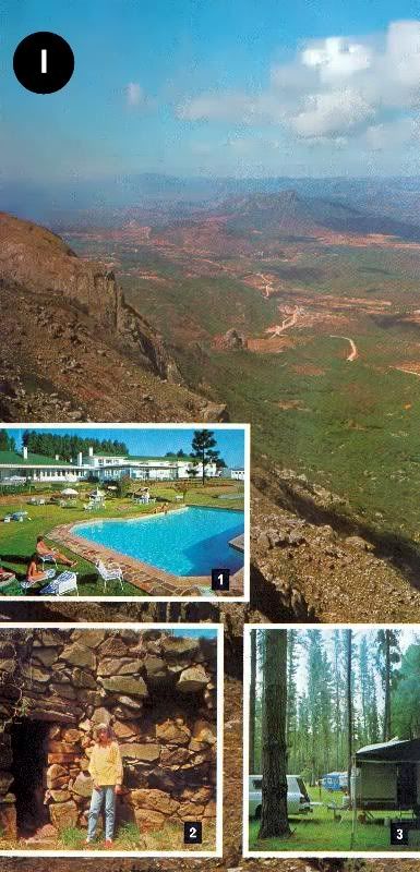
From this lofty vantage point the visitor may look down on the Valley of Ruins (main picture above), where a number of individual ruins are dominated by the Temple, or Great Enclosure, with its walls over ten metres high.
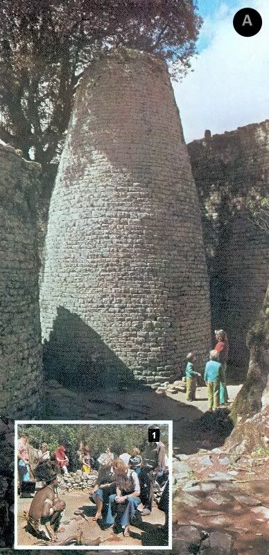
The most striking feature within the Temple ruin is the Conical Tower (main picture left), which is 10 metres high with a base circumference of 17 metres. The purpose of this magnificent example of dry-stone masonry has defied explanation, although many scientific observers believe it was associated with fertility rites.
To wander through the many passageways in the ruins, always with the Acropolis hill towering over all (inset B3) is an opportunity for the visitor to speculate on the Rhodesia of the past. The compelling atmosphere of this ancient site is a memory that will always remain with the visitor.
Near the ruins is a reconstruction of a Karanga village, which illustrates the way of life of the local people at the time of the discovery of Zimbabwe. Huts and artifacts have been painstakingly re-created, and a potter may be seen at work making pots by the ancient African method — without the aid of a potter's wheel. A popular figure here is the witchdoctor, who will "throw the bones" and tell one's fortune (inset A1).
While the charm of Zimbabwe is its ancient origin and unspoiled setting, the visitor may enjoy, at a choice of hotels, the provision of modern amenities and comforts (inset B4). The caravaner and camper is also well provided for.
LAKE KYLE
Lake Kyle is an instance, all too rare in the 20th century, where man has enhanced nature and through economic necessity created an environment that is useful and beautiful and which has encouraged wild life to increase in both variety and numbers.
In common with all the many lakes in Rhodesia, Lake Kyle is man-made, created when the 60-metre-high Kyle Dam (inset C1) was built across the Mtilikwe River. The intention was purely utilitarian, as part of a vast water-storage system for the agricultural schemes in the South-Eastern Lowveld, but with 90 square kilometres of lake, bordered by mountains (main picture above), the tourist appeal of the area has been considerably enhanced.
The lake lies 35 kilometres from the historic town of Fort Victoria. This was the first town established by the Pioneer Column after it had laboured its way up from the low country that was then the domain of the warlike Matabele.
During the Matabele War and Matabele Rebellion in the 1890s it was an important strong point. In the centre of the town, two of the towers of the original pioneer fort still stand (inset C2), and each night the curfew bell is still rung, as it was in the days of danger now long past.
The pioneer museum in the town is well worth visiting, and there is a visitor-information bureau in the main street.
To protect the new natural resource created by Lake Kyle, the lake, and much of the land bordering it now form the Kyle Recreational Park. On the northern shore is an 8 900-hectare game park, which has been stocked with species from all over Rhodesia. The visitor may drive around the park and see a great variety of antelope, and also giraffe.
The largest species here is the white rhino, which have formed breeding groups.
A particularly exciting way of game- viewing is on pony trails operated by the Recreational Park's staff ( picture D, lower right). Within this reserve are lodges and a camping and caravan site.
The keen animal photographer has additional opportunities for close-ups at a private game farm on the southern shore of the lake. Here lion (picture D) young elephant (inset D4) and other species may be closely approached.
The lake has proved ideal for all water sports (inset C3) and yachting and power-boating clubs are very active. To enable the visitor to enjoy the lake scenery, establishments provide boats for hire, for conducted trips and for water-skiing.
For the fisherman, Lake Kyle provides the best fishing for black bass in the country, and an annual international competition attracts anglers from all over Southern Africa. In addition to the bass, there are many other species to provide good sport.
The motorist may drive around the lake on a scenic road that passes through a variety of scenery, passing through tribal trust land, skirting the Nyuni Mountains, and returning through Fort Victoria. This scenic route may be combined with a visit to the north bank game reserve, with the return to the southern shore being made by car ferry.
SOUTH-EASTERN LOWVELD
For untold centuries this great area, comprising Rhodesia's south-eastern corner, where the land falls away from the central plateau, lay fallow. It was the home of game animals and a handful of tribesmen who lived an isolated life. The region's harshness was their protection against invaders.
Each summer the short, life-giving rains turned the rivers into torrents. During the long dry season the river-beds were dry gullies, and the potentially fertile land lay exhausted, parched and brittle.
The key to the Lowveld's riches was water, and as the area's rainfall was low, it had to be supplied by irrigation. Fortunately, although the region is dry, approximately half of Rhodesia's rain flowed down the catchment areas of the three main rivers — the Sabi, Lundi and Limpopo.
With the expenditure of millions of dollars an impressive system of large dams has been created (Lake Kyle is one) in these catchment areas, and the precious water that was once lost each rainy season is now stored and used over the whole year.
The availability of this water has permitted the development of vast agricultural estates, carved out of virgin bush in recent years. Side by side with bushveld, the visitor may see plains of wheat (picture E left), fields of green sugar cane and processing factories (main picture, bottom left).
To provide the services necessary for this expanding area, an administrative centre has been created at Chiredzi, and among the amenities are two modern hotels. A regular air service also connects the Lowveld with other centres in Rhodesia.
For the motorist passing through Chiredzi, a diversion to the famous Chipinda Pools on the Lundi River may afford a view of hippo basking on the bank (inset E1).
While the vast agricultural development, covering thousands of hectares, is impressive, the South-Eastern Lowveld is still, basically, an undeveloped area, and away from the estates there are large areas of land which are still the home of a wide variety of game animals. As these animals exist on private land, a professional hunting service is offered to visitors all the year round.
CHIMANIMANI MOUNTAINS
Driving eastwards from Fort Victoria, or north from the South-Eastern Lowveld, the visitor passes through typical lowveld scenery, characterised by lean Mopani forests and the occasional giant baobab. The highlands which dominate Rhodesia's eastern border for over 300 kilometres appear only as a blue mass against a bluer sky.
The principal gateway to this area from the west is the 358-metre silver span of the
Birchenough Bridge, (inset F3), built in 1935. This bridge carries the visitor across the broad, sand banked Sabi River, marking an end to the lowveld.
Soon the foothills are reached, and the road, constantly climbing, passes through cool green tea estates to Gazaland and the Chimanimani Mountains ( picture F, top right).
These are the southern bastion of the Eastern Highlands, and the most rugged mountains in the country.
The superb peaks, rising to over 2 500 metres, dominate the eastern horizon of the small administrative township of Melsetter, the nearest centre to the mountains.
Among the other tourist sights of this border area are the beautiful, 50-metre-high Bridal Veil Falls (inset F2) and an eland sanctuary, where a small herd of this, the largest antelope, may be seen.
Driving northward to Umtali, the motorist may take one of Rhodesia's finest scenic roads, via Cashel (main picture bottom right).
UMTALI
The city of Umtali (population 52 000, all races) is set halfway along the line of the Eastern Highlands, where the roads from Melsetter, Salisbury and Inyanga meet. Situated among steep, wooded hills, and attractively laid out with wide, tree-lined streets, it lays a strong claim to be Rhodesia's most beautiful town.
Reinforcing this claim are its modern civic centre (picture G) and its extensive parks (inset G2).
A history of this part of the Eastern Highlands is graphically shown in the local museum, which also has a transport gallery showing examples of horse-drawn carriages (G1) and early locomotives.
The city offers good shopping, entertainment and sporting facilities, and a choice of modern hotels and camping and caravan facilities. There is also a visitor-information bureau.
Thirteen kilometres from Umtali is La Rochelle, the beautiful home of the late Sir Stephen and Lady Courtauld (picture G bottom). Here 14 hectares of gardens include rare orchids, unusual trees and ornamental shrubs.
The grounds display a variety of formal gardens and careful landscaping. There are also numerous water gardens, waterfalls and fountains — all within the setting of the forested Penhalonga Valley.
VUMBA MOUNTAINS
A few kilometres outside Umtali the road to the Vumba begins its scenic climb, winding through steep mountains and rolling farmland. At each turn, new vistas over the surrounding countryside are revealed, and viewpoints have been created at appropriate locations.
Twenty-nine kilometres from Umtali, after passing through the dense Bunga Forest, the colourful Vumba Botanical Garden is reached. Here there are 30 hectares of landscaped flower gardens set within a larger area of natural woodland on the eastern slopes of the mountains.
Indigenous and exotic flora provide year-round colour ( picture H top) and the hydrangeas, azaleas and fuchsias here are numbered in their thousands.
The name Vumba means "mist", and the sight from one's hotel of the mountain peaks appearing through morning clouds gives the area a fairy-like quality ( picture H bottom).
The hotels in this holiday area each have their individual charm and appeal (inset H3) and are well provided with recreational amenities. There are also caravan and camping facilities within the botanical gardens.
INYANGA MOUNTAINS
Inyanga has the distinction of being the location of Rhodesia's highest mountain, Mt. Inyangani (2 790 metres), and although part of the Eastern Highlands chain, has its own unique character. The elevation is generally high, but the country is open and accessible, and this has led to its establishment as a firm favourite with Rhodesians themselves.
In times past the mountains were a place of refuge for African tribes, under pressure from invading peoples and they have left their ruined settlements and forts (inset I2) as evidence of their long occupation. These ruins cover both upland and lowland areas at Inyanga.
There is also a strong historical association with Cecil Rhodes, for he was so attracted to Inyanga that he purchased an enormous estate, which on his death formed the nucleus of the Inyanga National Park. One hotel incorporates his old homestead within its structure.
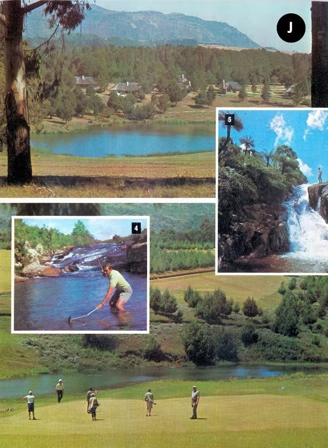
Due to its abundance of clear rushing streams, trout have been introduced and have thrived, providing anglers with superb, and cheap, sport (inset J4). Small lakes have also been created and stocked, and, on the shores of some, National Park lodges have been built for holiday makers (picture J top).
The visitor to Inyanga may roam at will, and those interested in flora and fauna will find much of interest. The unique aloe inyangensis may be found on the slopes of the mountain from which it takes its name, and the dwarf msasa forests which clothe many westward-facing slopes are a botanical curiosity. Bird life in this region of forest and moorland is very rich, and birds of prey are particularly plentiful.
Scenic drives have been created throughout the park area, leading to a number of spectacular water falls (cover, and inset J5).
As a popular holiday area, the choice of accommodation is wide, from hotels (inset I1) to caravan and camping sites set within pine forests (inset I3). Recreational facilities are good and there are three golf courses at Inyanga. The golfer will find good courses at most centres described in this brochure.
For those interested in African crafts, a weaving centre in the valley below Inyanga provides the visitor with an opportunity to see how this fascinating work is done, and purchases of the thick sheep's wool rugs with traditional patterns may be made.
Here at Inyanga, as elsewhere in the Eastern Highlands, it is the scenery, above all, that captivates. The eye moves naturally to the horizon-wide vistas of mountain and plain ( picture I top) and the clear air encourages even the least energetic visitor to stroll along winding footpaths and through fragrant pine forests.
FOR FURTHER INFORMATION
Local, detailed information on the areas described in this brochure is provided by publicity associations in the two principal centres. Enquiries relating to hotels, shopping facilities, banking and other services should be addressed to these associations, which maintain information bureaux.
In the Fort Victoria, Kyle and Zimbabwe area, the Fort Victoria/Zimbabwe Publicity Association, P.O. Box 340, Fort Victoria, will supply all the information required, and provide local maps and brochures.
For the Eastern Highlands, the Manicaland Development & Publicity Association, P.O. Box 69, Umtali, will provide the same services.
For information, maps and brochures on other parts of Rhodesia, enquiries should be made to the Rhodesia National Tourist Board, P.O. Box 8052, Causeway, Salisbury, Rhodesia. The board also maintains offices in Johannesburg (Tower Mall Upper, Carlton Centre, Commissioner St.), Durban (315 Smith St., Durban Club Place), and Cape Town (2219 Trust Bank Centre, cnr. Adderley & Riebeeck Streets).
FOR MOTORISTS
While petrol rationing is in force in Rhodesia, visitors are permitted as much petrol as they require for an enjoyable motoring holiday. Petrol is available seven days a week, and in urban areas, until 8 p.m.
The maximum speed permitted on Rhodesian roads, outside the normal restrictions in urban areas, is 100 k/h. This applies to both cars and cars towing caravans or trailers.
Repair facilities are not normally available at Rhodesian garages on Saturday or Sunday. Emergency repairs are provided at the discretion of proprietors.
End of Article
© RHODESIA CALLS (PVT.) LTD. REPRINTED FROM RHODESIA CALLS BY MARDON PRINTERS, SALISBURY
FOR THE RHODESIA NATIONAL TOURIST BOARD.
Recompiled, by Eddy Norris, from a copy of the booklet made available by Diarmid Smith. Thanks Diarmid
The recompilation was done for no or intended financial gain but rather to record the memories of Rhodesia.
Thanks to
Paul Norris for the ISP sponsorship.
Paul Mroz for the image hosting sponsorship.
Robb Ellis for his assistance.
Should you wish to contact Eddy Norris please mail him on orafs11@gmail.com

For over 100 years the Zimbabwe Ruins have been described as "one of Africa's greatest mysteries", and "the age-old riddle". Since their discovery in the mid-nineteenth century they have intrigued not only archaeologists and other specialists, but also the many visitors who have been attracted by the brooding atmosphere and the enigma of a vanished society.
Today, the scientific controversy is still not entirely resolved, although most expert opinion believes that Zimbabwe flourished from AD 1200 to 1450.
However, there is no questioning the fact that these are the largest single complex of ruins in Africa south of the Sahara.
The ruins of Zimbabwe were known to have existed as early at 1862. Adam Render, a hunter living in the area at that time, certainly knew of them, but their exact location was made known to the world by Carl Mauch in 1871.
Zimbabwe is believed to have been a mini-state, based on gold trade with the Arabs. Articles from China, India and Arabia have been excavated, and some are on display in a small museum at the ruins.
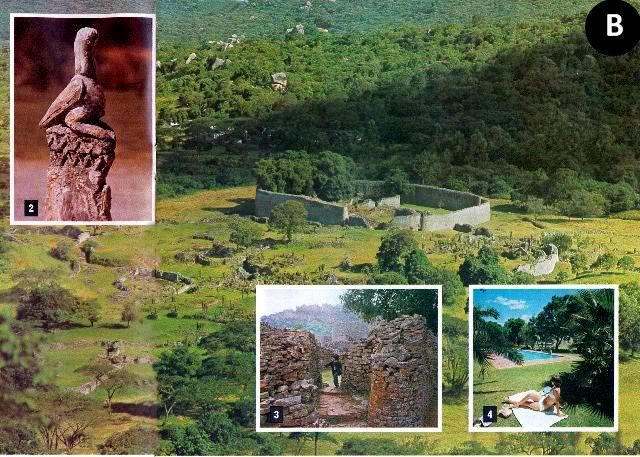
Among the most mysterious finds were the soapstone Zimbabwe birds (inset B2), which may have been chiefly totems.
The earliest ruins are to be found on what is called the Acropolis, a high hill where intricate dry-stone walls seem to cling precariously to the steep granite slopes, incorporating huge boulders in their course. Some of the most interesting archaeological finds were made in this complex of ruins.
From this lofty vantage point the visitor may look down on the Valley of Ruins (main picture above), where a number of individual ruins are dominated by the Temple, or Great Enclosure, with its walls over ten metres high.
The most striking feature within the Temple ruin is the Conical Tower (main picture left), which is 10 metres high with a base circumference of 17 metres. The purpose of this magnificent example of dry-stone masonry has defied explanation, although many scientific observers believe it was associated with fertility rites.
To wander through the many passageways in the ruins, always with the Acropolis hill towering over all (inset B3) is an opportunity for the visitor to speculate on the Rhodesia of the past. The compelling atmosphere of this ancient site is a memory that will always remain with the visitor.
Near the ruins is a reconstruction of a Karanga village, which illustrates the way of life of the local people at the time of the discovery of Zimbabwe. Huts and artifacts have been painstakingly re-created, and a potter may be seen at work making pots by the ancient African method — without the aid of a potter's wheel. A popular figure here is the witchdoctor, who will "throw the bones" and tell one's fortune (inset A1).
While the charm of Zimbabwe is its ancient origin and unspoiled setting, the visitor may enjoy, at a choice of hotels, the provision of modern amenities and comforts (inset B4). The caravaner and camper is also well provided for.

LAKE KYLE

Lake Kyle is an instance, all too rare in the 20th century, where man has enhanced nature and through economic necessity created an environment that is useful and beautiful and which has encouraged wild life to increase in both variety and numbers.
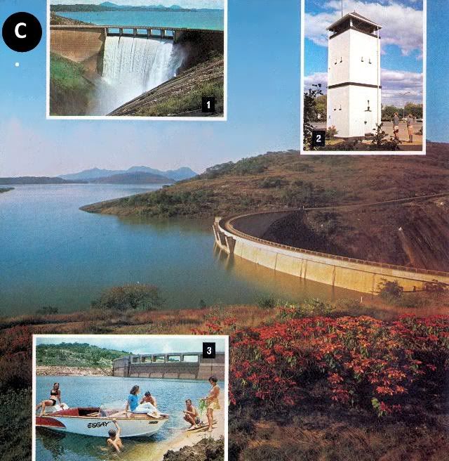
In common with all the many lakes in Rhodesia, Lake Kyle is man-made, created when the 60-metre-high Kyle Dam (inset C1) was built across the Mtilikwe River. The intention was purely utilitarian, as part of a vast water-storage system for the agricultural schemes in the South-Eastern Lowveld, but with 90 square kilometres of lake, bordered by mountains (main picture above), the tourist appeal of the area has been considerably enhanced.
The lake lies 35 kilometres from the historic town of Fort Victoria. This was the first town established by the Pioneer Column after it had laboured its way up from the low country that was then the domain of the warlike Matabele.
During the Matabele War and Matabele Rebellion in the 1890s it was an important strong point. In the centre of the town, two of the towers of the original pioneer fort still stand (inset C2), and each night the curfew bell is still rung, as it was in the days of danger now long past.
The pioneer museum in the town is well worth visiting, and there is a visitor-information bureau in the main street.
To protect the new natural resource created by Lake Kyle, the lake, and much of the land bordering it now form the Kyle Recreational Park. On the northern shore is an 8 900-hectare game park, which has been stocked with species from all over Rhodesia. The visitor may drive around the park and see a great variety of antelope, and also giraffe.
The largest species here is the white rhino, which have formed breeding groups.
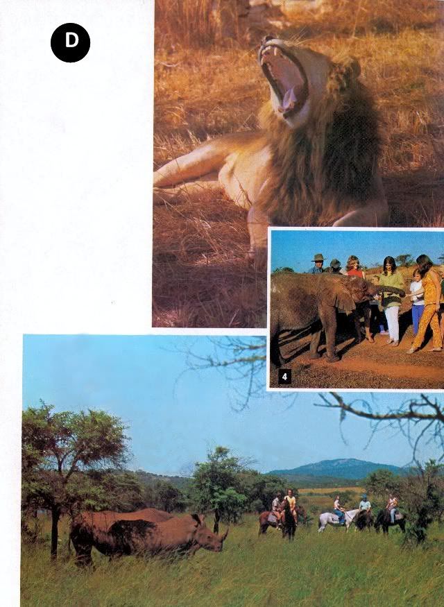
A particularly exciting way of game- viewing is on pony trails operated by the Recreational Park's staff ( picture D, lower right). Within this reserve are lodges and a camping and caravan site.
The keen animal photographer has additional opportunities for close-ups at a private game farm on the southern shore of the lake. Here lion (picture D) young elephant (inset D4) and other species may be closely approached.
The lake has proved ideal for all water sports (inset C3) and yachting and power-boating clubs are very active. To enable the visitor to enjoy the lake scenery, establishments provide boats for hire, for conducted trips and for water-skiing.
For the fisherman, Lake Kyle provides the best fishing for black bass in the country, and an annual international competition attracts anglers from all over Southern Africa. In addition to the bass, there are many other species to provide good sport.
The motorist may drive around the lake on a scenic road that passes through a variety of scenery, passing through tribal trust land, skirting the Nyuni Mountains, and returning through Fort Victoria. This scenic route may be combined with a visit to the north bank game reserve, with the return to the southern shore being made by car ferry.

SOUTH-EASTERN LOWVELD

For untold centuries this great area, comprising Rhodesia's south-eastern corner, where the land falls away from the central plateau, lay fallow. It was the home of game animals and a handful of tribesmen who lived an isolated life. The region's harshness was their protection against invaders.
Each summer the short, life-giving rains turned the rivers into torrents. During the long dry season the river-beds were dry gullies, and the potentially fertile land lay exhausted, parched and brittle.
The key to the Lowveld's riches was water, and as the area's rainfall was low, it had to be supplied by irrigation. Fortunately, although the region is dry, approximately half of Rhodesia's rain flowed down the catchment areas of the three main rivers — the Sabi, Lundi and Limpopo.
With the expenditure of millions of dollars an impressive system of large dams has been created (Lake Kyle is one) in these catchment areas, and the precious water that was once lost each rainy season is now stored and used over the whole year.
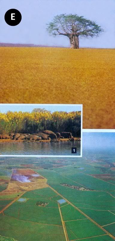
The availability of this water has permitted the development of vast agricultural estates, carved out of virgin bush in recent years. Side by side with bushveld, the visitor may see plains of wheat (picture E left), fields of green sugar cane and processing factories (main picture, bottom left).
To provide the services necessary for this expanding area, an administrative centre has been created at Chiredzi, and among the amenities are two modern hotels. A regular air service also connects the Lowveld with other centres in Rhodesia.
For the motorist passing through Chiredzi, a diversion to the famous Chipinda Pools on the Lundi River may afford a view of hippo basking on the bank (inset E1).
While the vast agricultural development, covering thousands of hectares, is impressive, the South-Eastern Lowveld is still, basically, an undeveloped area, and away from the estates there are large areas of land which are still the home of a wide variety of game animals. As these animals exist on private land, a professional hunting service is offered to visitors all the year round.
CHIMANIMANI MOUNTAINS

Driving eastwards from Fort Victoria, or north from the South-Eastern Lowveld, the visitor passes through typical lowveld scenery, characterised by lean Mopani forests and the occasional giant baobab. The highlands which dominate Rhodesia's eastern border for over 300 kilometres appear only as a blue mass against a bluer sky.
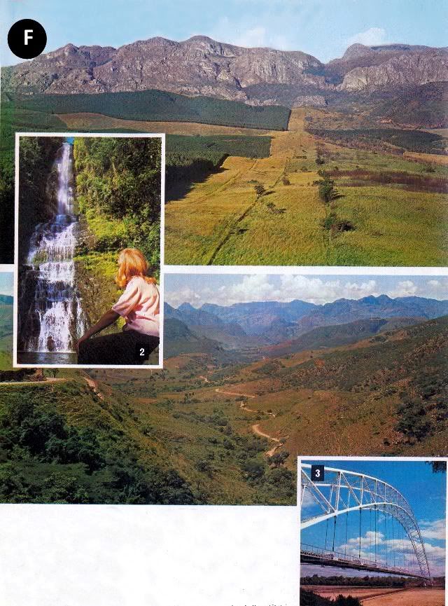
The principal gateway to this area from the west is the 358-metre silver span of the
Birchenough Bridge, (inset F3), built in 1935. This bridge carries the visitor across the broad, sand banked Sabi River, marking an end to the lowveld.
Soon the foothills are reached, and the road, constantly climbing, passes through cool green tea estates to Gazaland and the Chimanimani Mountains ( picture F, top right).
These are the southern bastion of the Eastern Highlands, and the most rugged mountains in the country.
The superb peaks, rising to over 2 500 metres, dominate the eastern horizon of the small administrative township of Melsetter, the nearest centre to the mountains.
Among the other tourist sights of this border area are the beautiful, 50-metre-high Bridal Veil Falls (inset F2) and an eland sanctuary, where a small herd of this, the largest antelope, may be seen.
Driving northward to Umtali, the motorist may take one of Rhodesia's finest scenic roads, via Cashel (main picture bottom right).
UMTALI

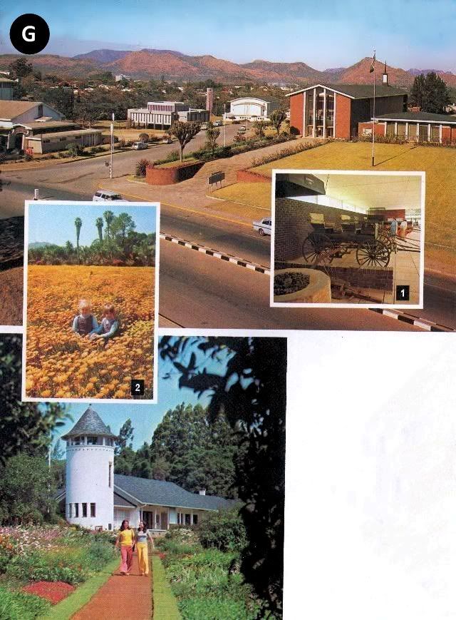
The city of Umtali (population 52 000, all races) is set halfway along the line of the Eastern Highlands, where the roads from Melsetter, Salisbury and Inyanga meet. Situated among steep, wooded hills, and attractively laid out with wide, tree-lined streets, it lays a strong claim to be Rhodesia's most beautiful town.
Reinforcing this claim are its modern civic centre (picture G) and its extensive parks (inset G2).
A history of this part of the Eastern Highlands is graphically shown in the local museum, which also has a transport gallery showing examples of horse-drawn carriages (G1) and early locomotives.
The city offers good shopping, entertainment and sporting facilities, and a choice of modern hotels and camping and caravan facilities. There is also a visitor-information bureau.
Thirteen kilometres from Umtali is La Rochelle, the beautiful home of the late Sir Stephen and Lady Courtauld (picture G bottom). Here 14 hectares of gardens include rare orchids, unusual trees and ornamental shrubs.
The grounds display a variety of formal gardens and careful landscaping. There are also numerous water gardens, waterfalls and fountains — all within the setting of the forested Penhalonga Valley.
VUMBA MOUNTAINS

A few kilometres outside Umtali the road to the Vumba begins its scenic climb, winding through steep mountains and rolling farmland. At each turn, new vistas over the surrounding countryside are revealed, and viewpoints have been created at appropriate locations.
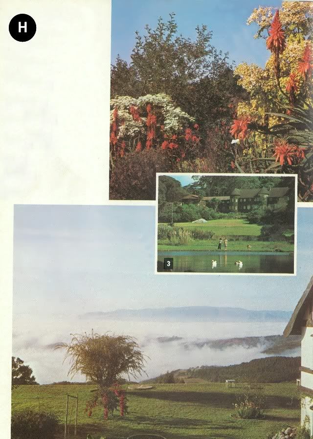
Twenty-nine kilometres from Umtali, after passing through the dense Bunga Forest, the colourful Vumba Botanical Garden is reached. Here there are 30 hectares of landscaped flower gardens set within a larger area of natural woodland on the eastern slopes of the mountains.
Indigenous and exotic flora provide year-round colour ( picture H top) and the hydrangeas, azaleas and fuchsias here are numbered in their thousands.
The name Vumba means "mist", and the sight from one's hotel of the mountain peaks appearing through morning clouds gives the area a fairy-like quality ( picture H bottom).
The hotels in this holiday area each have their individual charm and appeal (inset H3) and are well provided with recreational amenities. There are also caravan and camping facilities within the botanical gardens.
INYANGA MOUNTAINS

Inyanga has the distinction of being the location of Rhodesia's highest mountain, Mt. Inyangani (2 790 metres), and although part of the Eastern Highlands chain, has its own unique character. The elevation is generally high, but the country is open and accessible, and this has led to its establishment as a firm favourite with Rhodesians themselves.
In times past the mountains were a place of refuge for African tribes, under pressure from invading peoples and they have left their ruined settlements and forts (inset I2) as evidence of their long occupation. These ruins cover both upland and lowland areas at Inyanga.
There is also a strong historical association with Cecil Rhodes, for he was so attracted to Inyanga that he purchased an enormous estate, which on his death formed the nucleus of the Inyanga National Park. One hotel incorporates his old homestead within its structure.

Due to its abundance of clear rushing streams, trout have been introduced and have thrived, providing anglers with superb, and cheap, sport (inset J4). Small lakes have also been created and stocked, and, on the shores of some, National Park lodges have been built for holiday makers (picture J top).
The visitor to Inyanga may roam at will, and those interested in flora and fauna will find much of interest. The unique aloe inyangensis may be found on the slopes of the mountain from which it takes its name, and the dwarf msasa forests which clothe many westward-facing slopes are a botanical curiosity. Bird life in this region of forest and moorland is very rich, and birds of prey are particularly plentiful.
Scenic drives have been created throughout the park area, leading to a number of spectacular water falls (cover, and inset J5).
As a popular holiday area, the choice of accommodation is wide, from hotels (inset I1) to caravan and camping sites set within pine forests (inset I3). Recreational facilities are good and there are three golf courses at Inyanga. The golfer will find good courses at most centres described in this brochure.
For those interested in African crafts, a weaving centre in the valley below Inyanga provides the visitor with an opportunity to see how this fascinating work is done, and purchases of the thick sheep's wool rugs with traditional patterns may be made.
Here at Inyanga, as elsewhere in the Eastern Highlands, it is the scenery, above all, that captivates. The eye moves naturally to the horizon-wide vistas of mountain and plain ( picture I top) and the clear air encourages even the least energetic visitor to stroll along winding footpaths and through fragrant pine forests.

FOR FURTHER INFORMATION
Local, detailed information on the areas described in this brochure is provided by publicity associations in the two principal centres. Enquiries relating to hotels, shopping facilities, banking and other services should be addressed to these associations, which maintain information bureaux.
In the Fort Victoria, Kyle and Zimbabwe area, the Fort Victoria/Zimbabwe Publicity Association, P.O. Box 340, Fort Victoria, will supply all the information required, and provide local maps and brochures.
For the Eastern Highlands, the Manicaland Development & Publicity Association, P.O. Box 69, Umtali, will provide the same services.
For information, maps and brochures on other parts of Rhodesia, enquiries should be made to the Rhodesia National Tourist Board, P.O. Box 8052, Causeway, Salisbury, Rhodesia. The board also maintains offices in Johannesburg (Tower Mall Upper, Carlton Centre, Commissioner St.), Durban (315 Smith St., Durban Club Place), and Cape Town (2219 Trust Bank Centre, cnr. Adderley & Riebeeck Streets).
FOR MOTORISTS
While petrol rationing is in force in Rhodesia, visitors are permitted as much petrol as they require for an enjoyable motoring holiday. Petrol is available seven days a week, and in urban areas, until 8 p.m.
The maximum speed permitted on Rhodesian roads, outside the normal restrictions in urban areas, is 100 k/h. This applies to both cars and cars towing caravans or trailers.
Repair facilities are not normally available at Rhodesian garages on Saturday or Sunday. Emergency repairs are provided at the discretion of proprietors.
End of Article
© RHODESIA CALLS (PVT.) LTD. REPRINTED FROM RHODESIA CALLS BY MARDON PRINTERS, SALISBURY
FOR THE RHODESIA NATIONAL TOURIST BOARD.
Recompiled, by Eddy Norris, from a copy of the booklet made available by Diarmid Smith. Thanks Diarmid
The recompilation was done for no or intended financial gain but rather to record the memories of Rhodesia.
Thanks to
Paul Norris for the ISP sponsorship.
Paul Mroz for the image hosting sponsorship.
Robb Ellis for his assistance.
Should you wish to contact Eddy Norris please mail him on orafs11@gmail.com
posted by Rhodesia Remembered @ 10:16
1 Comments
![]()
![]()


1 Comments:
very nice may be you like this please read hi everyone Your one-stop site for all Indian Lottery Results and information, including Sambad, Kerala, Goa State, Sikkim and Punjab lottery games it's very nice
Post a Comment
Subscribe to Post Comments [Atom]
<< Home